
Geographical data in the Vedic texts, ancient Indian scriptures dating back more than 3,000 years, offer valuable insights into the geography of the Indian subcontinent at this time. These sacred texts, including the Rigveda, mention various rivers, mountains, and regions and provide insight into how the Vedic people understood their environment.
Prominent references include the sacred Sarasvati River, often associated with the modern Ghaggar-Hakra river system, and the mighty Indus River, which played a significant role in the Vedic civilization. The Himalayan mountains are worshiped and mentioned as a symbol of grandeur and divinity.
Vedic texts also describe the division of the subcontinent into distinct regions, known as “doshas”, and the importance of geographical features in rituals and hymns.
While these texts offer valuable historical and cultural insights, their interpretation in a contemporary geographic context can be challenging due to changes in river courses and landscapes over the millennia. Nevertheless, they remain essential sources for understanding the ancient geography of the Indian subcontinent and its cultural significance.
Geographical Data in the Vedic Texts
| Historical Facts | Geographical Data in the Vedic Texts |
| Mountain | The Himalaya |
| Rivers | Sindhu, Ganga, and Yamuna |
| Sutlej | Sutudri |
| Insignificant Stream | Saraswati |
| Jhelum | Vitasta |
| Chenab | Asikni |
| Ravi | Parusni |
| Beas | Bipasha |
Introduction: Geographical data in Vedic texts
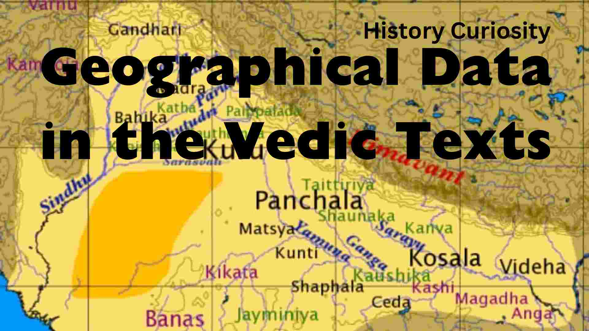
From the geographical data of the Vedic civilization given in the Rigveda, we can analyze the course of Aryan expansion in North India. It is a reasonable assumption that the geographical names that figure prominently or frequently in these hymns denote regions that were known to their authors and were the scene of early Aryan activity. Names less conspicuous or frequent may be either outside Aryan settlements or border areas inhabited by non-Aryans. For example, when the early Rigvedic hymns were written, the focus of Aryan culture was the region between the Yamuna and the Sutudri (Sutlej) and along the upper reaches of the Saraswati River. The other river is now an insignificant stream lost in the desert of Rajasthan, but then it flowed wide and strong. The Rigvedic poets knew the Himalayas but not the country south of the Yamuna and did not mention the Vindhyas.
Geographical data in Vedic texts
To ascertain the extent of the Aryan settlements in the Rigvedic or early Vedic age, we should therefore take into account the references to mountains, rivers, localities, tribes, and kingdoms contained in the hymns. River courses, especially in the Punjab, have changed considerably over the past three or four millennia. Their names also varied at different times. Thus, there is some difference of opinion regarding the names of the rivers mentioned in the Vedic literature or texts. The same goes for the location of the various tribes and countries. But in spite of these difficulties, it is possible to form a fair idea of the geographical data figured in the Vedic texts.
Earth
The Aryans used the term Sapta Sindhava to refer to the area where they settled. They used the term in the context of the country. Elsewhere, the term is also intended in the context of seven rivers—the five rivers of the Punjab, along with the Indus and the Saraswati. The word India corresponds to Sindhu (Indus) or Hindu in old Persian epigraphs. Closely related to “Hindu” are the latter designations “Hind” or “Hindustan,” as used by medieval Muslim historians. The Bharatas were the most important Aryan tribe, after whom the whole country came to be called ‘Bharata’. The land of the Aryans was also designated as Aryavarta (Aryandom) in recent scriptures.
Mountains
The Himalayas or Himavanta mountains are mentioned, but not the Vindhyas or the Satpuras. Thus the Rigvedic Aryans had evidently not yet established settlements in the southern directions. As the main ridge rises above the line of eternal snow, the name Himavanta or Himalaya (i.e. “mountain clothed in the show”) was well coined by the ancient geographers of India. Other hills mentioned are Arjika, Mujavant, Silament (Sulaiman range), etc. which were all ranges of the Himalayas.
Rivers
In the Rigvedic age, rivers were considered sacred because of the immense benefits they provided to mankind. Of the thirty-one rivers mentioned in the Vedic texts, about twenty-five names occur only in the hymns of the Rigveda. In the famous Nadistuti (X 75) the Rigveda enumerates several streams, most of which belong to the Indus system. Seven major rivers and several small rivers were often mentioned. Since Vedic times, it has become almost a convention to describe the gradually expanding Aryandom by seven rivers called “Sindhu”. Thus the entire land occupied by the Rigvedic Aryans was designated as Sapta Sindhu, specifically the five rivers of Punjab along with Sindhu and one more (perhaps Saraswati or Khubha or Oxus). When the Aryan Dome embraced the whole of India, the name Sapta Sindhu was still retained and came to be represented by seven major rivers called Ganga, Yamuna, Godavari, Saraswati, Narmada, Sindhu and Kaveri.
(i) Sindhu
The Rigvedic Aryans considered the Sindhu to be an extraordinary river. He was the ‘lord and leader of the moving floods’. It was the western boundary of the then-Sapta Sindhava. The large number of tributaries of the Sindhu is recorded in the “Nadi Stuti” hymn of the Rigveda. Some of the important tributaries in its west are Krumu and Gomati. The five major tributaries in the east include ‘Vitasta’ (Jhelum), ‘Asikni’ (Chenab), ‘Parusni’ (Ravi), ‘Satadru’ (Sutlej) and ‘Bipasha’ (Beas).
(ii) Krum
Below Kubha (or Kabul) this Rigvedic river forms the western tributary of the Sindhu. It has been identified with the modern Kuram, which flows into the Indus at a point south of Ishakhed. It penetrates through the Suleman Mountains.
(iii) Khubha
Among the western tributaries of the Sindh, this Rigvedic river is the most important. It formed the western border of what was then India. It is none other than the modern Kabul river, which is identical to the “Kofen” river of Alexander’s historians. It flows into the Indus just above Attock.
(iv) Vitasta
It is the modern Jhelum and is the westernmost of the five rivers of Punjab. It flows through Srinagar and meets the Chenab below Jhang. It is the same as the Bidaspes or Hydaspes of the Greeks.
(v) Asikni
It is the modern Chenab and flows past Jammu and thence in a south-westerly direction, forming the doab between it and the Jhelum. Identification with the Chenab is ensured by the name Akesines given to him by Alexander’s historians and by Megasthenes.
(vi) Parushni
The War of Ten Kings was fought on the left bank of the Parushni. It has been identified with modern Ravi. It flows to Kashmir, Lahore, and then meets the Chenab. Its valley was famous for wool. Havyavati seems to be the other name of Ravi in the Rigveda. The Rigveda mentions that Indra wiped out the remnants of the Varashikhas at Hariyupiya on behalf of Abhyavartin Chayamana, an Aryan chief. The tribe destroyed was that of the Vricivats on the Havyavati River.
(vii) Satadru
Known as Zaradros in Ptolemy, it is modern Sutlej. The Rigveda describes it as the most easterly river of the Punjab. It is fed by the Manasarovar Lake. The united streams of the Sutlej and the Beas are known as Ghaggar. The river is praised because it checked its course and allowed the army of Bharat to cross safely.
(viii) Vipasa
It is a tributary of the Satadru and has been taken to be the modern Beas. Probably at the time of the Rigveda, it was an independent river. The river is fed by a number of glaciers. From Chamba, it flows in the south-westerly direction to meet the Satadru. It was on the bank of this river that Indra defeated Usas and broke his chariot to pieces. It was the Hyphasis of the Greeks and ‘Bibasis’ of Ptolemy.
(ix) Saraswati
It was known to the Rigvedic Aryans as a very mighty river that was visible in one place and invisible in another. She was the mother of all rivers (Saraswati Sapthathi Sindhumata). The river emanated forth from the Himalayas and partly survives today flowing between the Satadru and the Yamuna. It has been variously identified with the Harakhvati or Harahvati of Avesta, with Helmand, or with Hakra rivers. In the Rigveda, three epithets have been used for this river. These were ambitame, devitame and naditame.
(x) Drishadvati
It had no connection with the rivers of the Indus group. It is mentioned in the Rigveda and is described as the southern and eastern boundary of what was then known as ‘Brahmavarta’. It has been identified with Chautang.
(xi) Apaya
The Rigveda says that this river flowed between the Drishadvati and the Saraswati. It is a small tributary flowing past Thaneswar in Haryana.
(xii) Gomati
The Rigvedic Gomati has been identified with modern Gomal, a western tributary of the Indus. It should not be confused with the river of the same name that flows by Lucknow. The first reference to the name Gomal for the river occurs in Baburnama.
(xiii) Sarayu
According to the Rigveda, Chitrartha and Anna were defeated by the Turvasas and Yadus, who crossed this river. The reference in the Rigveda makes it certain that it was a trans-Indus river. It is called Haroya in the Avesta. However, it may have been the name of a river in Punjab. But there is no evidence to show the transfer of the name of the river to the one on which Ayodhya was to stand later.
(xiv) The Ganges
The Ganga is mentioned only twice in the Rigveda, and there is no separate verse in praise of the Ganga, which proves that although the river was famous in the Rigvedic period, it did not command the love and respect it acquired later. The obvious reason is that it was not in the area occupied by the Rigvedic Aryans. In the later Vedic period and thereafter, the Ganga replaced all other rivers, proving the eastward expansion of Aryandum.
(xv) Yamuna
It is mentioned three times in the Rigveda. Tritsus and Sudas defeated their enemies on the banks of this river. The territory of the Tritsus lay between the Yamuna and the Saraswati, on the east and west.
(xvi) Other River
A total of ninety-nine rivers are mentioned in the Rigveda. Fifteen major rivers are mentioned above. Some of the minor rivers were Rasa, Anumati, Asuniti, Raka, Gungu, Susoma, Marud-Vrdhas etc. However, in the later Vedic period some new rivers were known. The Sudaman was thus a tributary of the Beas. Varanavati, mentioned in the Atharvaveda, gave its name to Varanasi. Varanasi derives its name from the current river Barna (Varana) and another river Asi. The Sadanira (literally perennial), identified with the modern Gandak, was also one of the main rivers. The knowledge of Gandaka shows that the Vedic-speaking people have now moved to North Bihar.
Sea
The Rigvedic Aryans were not familiar with seas or oceans. M. L. Bhargava in his book The Geography of Rig Vedic India, has made several allusions to oceans as well as large ships, but in all probability words like ‘Samudra’, ‘arnav’, or ‘catch samudra’ refer to the vast waters of the Indus. However, in later Vedic literature, Samudra actually means sea. References to the eastern and western oceans in the Satapatha Brahmana indicate familiarity with the Bay of Bengal and the Arabian Sea.
Conclusion
The Rigvedic Aryans did not know any kind of desert. However, an implicit reference to Maria as a land of desert mounds near Kurukshetra has been traced in the Taittiriya Aranyaka. It was essentially a rural culture, and cities did not emerge; thus, no important place name is recorded. In the Rigveda, this was due to the migratory nature of the tribes, and in the later Vedic age, the regions came to be known by the names of the tribes that ruled them.
Videos about Iron Age civilization Geographical Data in the Vedic Texts
(FAQ) Questions and Answers about Geographical Data in the Vedic Texts
Q-1. Do the Vedic texts contain accurate geographical information?
Ans. Vedic texts such as the Rigveda primarily focus on religious and philosophical themes rather than providing detailed geographical data. Although they mention rivers like the Sarasvati, the exact locations remain debated among scholars.
Q-2. Is there any mention of a specific map or distribution of areas in the Vedic texts?
Ans. No, the Vedic texts do not provide a mapped-out distribution of areas. Descriptions are often symbolic or metaphorical, emphasizing spiritual and cosmic themes rather than geographical accuracy.
Q-3. Are the rivers mentioned in Vedic texts identifiable with modern rivers?
Ans. Identifying the mentioned rivers, such as the Sarasvati, with their modern counterparts is difficult. Scholars have different interpretations, and there is no consensus on the exact location.
Q-4. Do the Vedic texts offer insight into ancient civilizations or cultures?
Ans. Rather than providing a comprehensive view of ancient civilizations or cultures, the Vedic texts offer glimpses into ancient customs, rituals, and philosophical ideas.
Q-5. How do scholars approach the interpretation of geographical references in Vedic texts?
Ans. Scholars use linguistic analysis, archaeological findings, and comparative studies to interpret geographical references in the Vedic texts. However, it is necessary to approach these interpretations with caution due to the symbolic nature of many of the descriptions.
Q-6. Is there consensus among scholars regarding the interpretation of geographical features in the Vedic texts?
Ans. There is no universal consensus. Interpretations vary, and scholars may have different views on the geographical aspects of the Vedic texts, leading to constant discussions and debates in the field.